


BLACKLAND Voting District, Howard County, Arkansas
About
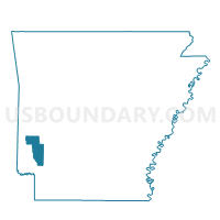
Outline

Summary
| Unique Area Identifier | 526663 |
| Name | BLACKLAND Voting District |
| County | Howard County |
| State | Arkansas |
| Area (square miles) | 15.18 |
| Land Area (square miles) | 15.00 |
| Water Area (square miles) | 0.18 |
| % of Land Area | 98.82 |
| % of Water Area | 1.18 |
| Latitude of the Internal Point | 33.81510210 |
| Longtitude of the Internal Point | -93.87365310 |
Maps


Graphs
Select a template below for downloading or customizing gragh for BLACKLAND Voting District, Howard County, Arkansas


Neighbors
Neighoring Voting District (by Name) Neighboring Voting District on the Map
- BUCK RANGE Voting District, Howard County, AR
- FRANKLIN Voting District, Howard County, AR
- Mine Creek Voting District, Hempstead County, AR
- Saline Voting District, Hempstead County, AR
- SARATOGA Voting District, Howard County, AR
- TOLLETTE Voting District, Howard County, AR
Top 10 Neighboring County Subdivision (by Population) Neighboring County Subdivision on the Map
- Mine Creek township, Hempstead County, AR (1,535)
- Saline township, Hempstead County, AR (712)
- Buck Range township, Howard County, AR (243)
- Tollette township, Howard County, AR (240)
- Saratoga township, Howard County, AR (214)
- Franklin township, Howard County, AR (201)
- Blackland township, Howard County, AR (171)